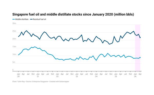
Pacific storm might make landfall in California this week
Hurricane Frank is currently drifting in a northwest to northeast boomerang curve from the Pacific Ocean towards the US West Coast.
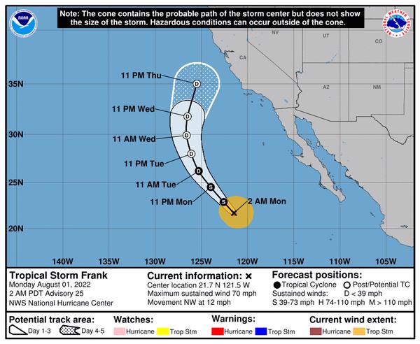 PHOTO: The US National Hurricane Center
The hurricane is expected to weaken into a tropical storm today and further to a tropical depression tomorrow. If it continues on its forecast path, it could reach the San Francisco area in California at the end of the week. Frank might have weakened even further by then.
According to the US National Hurricane Center, wind speeds of 74-100 mph qualify as a hurricane, 39-73 mph as a tropical storm and less than 39 mph as a tropical depression.
Accuweather hurricane expert Dan Kottlowski has predicted that this year's hurricane season will have “above-normal” tropical activity with a chance of a major hurricane making landfall in the US or Caribbean.
The US-based weather forecaster predicts there could be 16-20 named storms. Of these, 6-8 could become hurricanes, of which 3-5 could be classified as major hurricanes with wind speeds of more than 111 mph.
In August last year, Hurricane Ida flooded homes and knocked out power grids, ports, refineries and offshore oil platforms across Louisiana and the Gulf of Mexico.
More than 2 million b/d of refinery production was halted as refiners braced for the incoming hurricane, and major offshore oil rigs and platforms remained shut long after Ida lashed across the Gulf of Mexico.